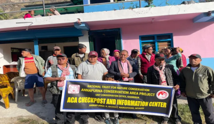
A tourist information centre and checkpost has come into operation at Banskot in Narachyang, the entry point of the Maurice Herzog trail in Annapurna Rural Municipality-4 of Myagdi district, adding a new point of support for trekkers heading toward the Annapurna Base Camp. The facility was set up through the joint initiative of the Annapurna Conservation Area Project (ACAP) and the local conservation area management committee, as reported by Gorkhapatra Online and Ratopati. Positioned where the trail begins, the centre is intended to serve the visitors who take the Myagdi-side route to the base camp of the Annapurna massif, one of Nepal's best-known trekking destinations.
A twin-purpose facility at the trailhead
The newly opened structure combines the two functions most useful at the start of a remote mountain trail: information and oversight. As its name suggests, the tourist information centre is meant to orient trekkers before they set off, while the accompanying checkpost gives authorities a formal record of who enters the route and when.
Facilities of this kind, now common along Nepal's trekking corridors, typically perform a cluster of related tasks. For the Banskot centre, these are expected to include:
- providing route information, basic guidance and safety-related advice to visitors before they begin the walk to Annapurna Base Camp;
- registering trekkers as they enter the trail, creating a record that becomes invaluable if anyone goes missing or needs rescue;
- monitoring the movement of people in and out of this section of the Annapurna Conservation Area; and
- serving as a first point of contact for visitor queries and trail conditions.
For trekkers, the practical difference is that the Maurice Herzog trail now has an institutional presence at its gateway. Rather than stepping onto the route with no point of contact, visitors arriving at Banskot will find a staffed structure whose purpose is to inform, register and assist them. For the conservation authorities, the checkpost strengthens the ability to keep track of footfall on a route that has been drawing attention as an alternative approach to the base camp.
ACAP and the community committee behind the initiative
The centre is a product of collaboration rather than a single actor's effort. ACAP and the local conservation area management committee jointly took the initiative to establish it, pairing the technical and institutional capacity of the protected-area authority with the grassroots body that represents the community living along the trail.
ACAP, established in 1986, was Nepal's first conservation area and remains the country's largest protected area, spreading across mountain districts that include Myagdi, Kaski, Manang, Mustang and Lamjung. Its defining feature is a community-based management model: local conservation area management committees, rooted in the resident population, handle day-to-day work ranging from forest protection to the management of tourism in their areas. The committee in Narachyang sits within that network, and its involvement in the Banskot centre follows the same logic that has made ACAP a widely cited example of conservation and tourism advancing together.
The arrangement also has a practical dimension. Trekking routes in the Annapurna region generate fees and economic activity that, under the conservation area model, are meant to flow back into local development. A formal information centre and checkpost at the trailhead gives the community a structured way to manage that flow from the very first step of the journey.
A trail named for a mountaineering landmark
The route's name carries its own weight of history. Maurice Herzog was the French mountaineer who led the 1950 expedition that achieved the first recorded ascent of an 8,000-metre peak anywhere in the world: Annapurna I, which rises to 8,091 metres. On 3 June 1950, Herzog and his teammate Louis Lachenal reached the summit, a feat that came at a severe physical cost (both men suffered extreme frostbite during the descent) but entered mountaineering legend. Herzog's account of the expedition, published as Annapurna, became one of the most celebrated mountaineering books ever written.
Naming the Myagdi trail after Herzog links the walking route to the climbing history of the mountain it approaches. The trail leads trekkers toward the Annapurna Base Camp, which sits at an altitude of around 4,130 metres and draws visitors from across the world. Most of that footfall has historically been concentrated on routes that begin on the Kaski side near Pokhara; the Myagdi approach through Narachyang offers an alternative corridor, and with it a potential share of the trekking economy for villages along the way.
What the centre could mean on the ground
For visitors, the immediate benefit is practical: reliable information and a formal entry point at Banskot, reducing the uncertainty that comes with starting a lesser-known route. For residents of Narachyang and the surrounding settlements, the centre signals an effort to build tourism infrastructure around the trail in a planned manner, with the local conservation area management committee among its backers rather than leaving the route to informal arrangements.
First stop on the Myagdi approach
The opening of the centre does not change the trail itself, but it changes how the trail is received. A named route with a staffed gateway and the backing of the conservation area's institutional network stands on firmer footing as trekking traffic develops. As interest in the Maurice Herzog trail grows, the Banskot centre is positioned to be the first stop of the Annapurna Base Camp journey for those who choose the Myagdi approach, and for the villages of Narachyang, a visible marker of their place on Nepal's trekking map.