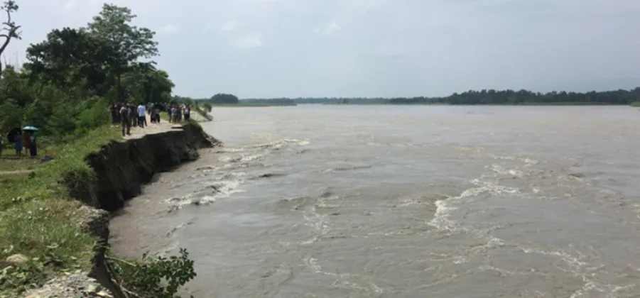
The Irrigation and Water Resources Management Project, based in Lamahi, has begun a scientific study and a master plan for the sustainable management of the Rapti River, with its work centred on Dang district. The initiative takes the western Rapti River watershed as its focal area and extends to the Deukhuri Valley and the areas surrounding it. Two questions sit at the heart of the research: how land use across the watershed is changing, and what consequences the rise in global temperatures may hold for the river system. Together, the study and the master plan are intended to give a scientific footing to decisions about how the river is used and protected in the years ahead.
The reports on the launch of the study have been published by RatoPati and Nagarik News.
A Watershed-Wide Scientific Exercise
The study announced by the Lamahi-based project is designed as a scientific exercise at the scale of the entire western Rapti watershed rather than a narrow survey of the river channel itself. In river management, a watershed approach is considered essential because what happens across the wider drainage area, from hill slopes to valley floors, ultimately determines how much water reaches the river, how much sediment it carries, and how severely it floods. By examining the whole catchment, the study aims to capture these upstream and downstream connections in one integrated picture.
Central to the exercise is the question of land use. Across Nepal's river basins, forests are cleared or regrow, farms expand or are converted, settlements spread, and roads and other infrastructure reshape the terrain, and each of these changes alters the way rainwater moves across the landscape. The study will document such shifts across the western Rapti watershed, building a record of how human activity is redrawing the basin.
The second strand of the study turns to climate, specifically the rise in global temperatures and the pressure it places on river systems. Warmer conditions influence rainfall, evaporation and the behaviour of rivers in both wet and dry seasons, which is why the project has placed temperature rise alongside land-use change as a core theme of the research.
The initiative has three core components:
- A scientific study of the western Rapti River watershed
- An examination of changes in land use and the impact of rising global temperatures
- A master plan for sustainable river management covering the Deukhuri Valley and surrounding areas
Focus on the Deukhuri Valley
The impact area defined for the study covers the Deukhuri Valley and its surroundings. The valley lies in Dang district and is the low-lying basin through which the river passes, home to communities whose livelihoods are tied closely to the river and its water. It is for this reason that the project office in Lamahi has framed the initiative as a plan for sustainable river management: the goal is not merely to study the river, but to ensure that its water, banks and surrounding land can continue to support the people living along it without being degraded in the process.
Sustainable management, as the term is used in the project, implies balancing the present use of the river with its long-term health. That balance is becoming harder to strike in many of Nepal's river basins as land use changes and temperatures climb, and this is precisely the problem the Dang study has been designed to investigate.
From Study to Master Plan
Alongside the scientific study, the project is preparing a master plan for the river. In practice, a master plan of this kind is a long-term guiding document: it draws on the evidence collected in the study and sets out how the river and its watershed should be managed, used and protected over time. For the Deukhuri Valley and the areas around it, the plan is expected to become the reference point against which future decisions about the western Rapti are weighed. The combination of the two exercises, a scientific study feeding into a master plan, is intended to ensure that the strategy for the river rests on evidence rather than assumption.
The work is being carried out by the Irrigation and Water Resources Management Project from its base in Lamahi, which is coordinating the study in Dang district. Details of the study's duration, cost and methodology were not included in the initial announcement.
The Wider Context
The initiative comes at a time when the pressures it examines, changing land use and rising temperatures, are increasingly visible across Nepal's river systems. Watersheds in hill and Terai districts are being reshaped by the expansion of cultivation and settlements, while shifts in temperature and rainfall alter the timing and intensity of river flows. For a river like the western Rapti, which drains a mixed landscape of hills and valley land before passing through the Deukhuri Valley, such pressures translate into practical concerns about where the river erodes its banks, where its water can be drawn for irrigation, and how floods behave in years of heavy rain.
A master plan grounded in a watershed-scale study is meant to answer these questions systematically. By documenting land-use change and factoring in temperature rise, the study underway in Dang district is expected to give planners a clearer picture of the forces at work on the river before decisions are taken about its future management.