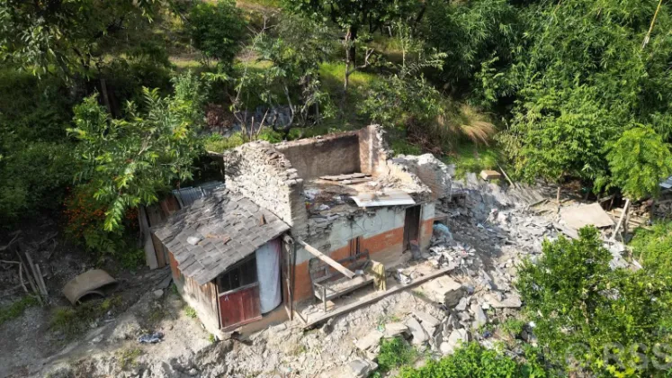
Rain-induced floods and landslides have affected 166 households in Mangala Rural Municipality of Myagdi district, according to damage details released by the local government. The disaster has completely damaged 17 houses, left 77 houses at high risk and rendered 72 houses vulnerable, while 572 ropanis of farmland have been damaged across the rural municipality. The floods and landslides also completely destroyed 12 livestock sheds, partially damaged 18 more and affected 20 roadways. Rural Municipality Chair Sat Prasad Rokha provided the details, which were reported by Rato Pati.
Housing Damage Leaves 166 Families Facing an Uncertain Future
The housing toll is the most striking element of the local government's assessment. Every one of the 166 affected households falls into one of three categories, reflecting how close each home stands to the danger triggered by the rains:
- 17 houses completely damaged
- 77 houses at high risk
- 72 houses vulnerable
Homes recorded as completely damaged can no longer serve as shelter for the families that lived in them, and those households now face the challenge of finding alternative accommodation. Houses classified as high risk are standing but considered unsafe for habitation, particularly if rainfall continues or the slopes around them shift further. The 72 houses listed as vulnerable could yet suffer damage if conditions in the area deteriorate. Taken together, the figures show that none of the affected households in Mangala Rural Municipality has escaped the threat entirely, whether the loss has already occurred or remains a real possibility.
Farmland and Livestock Sheds Suffer Heavy Losses
Beyond shelter, the disaster has damaged 572 ropanis of farmland in the rural municipality. The ropani is a traditional Nepali unit of land measurement equal to roughly 508 square meters, meaning the affected agricultural land amounts to approximately 29 hectares. In a hill municipality where farming sustains a large share of households, damage to cultivated land on this scale is a serious blow, since fields that are flooded or buried under debris may not produce crops in the coming season.
Livestock keeping, which in rural Myagdi is closely tied to farming, has also been hit. The floods and landslides completely destroyed 12 livestock sheds and partially damaged 18 others. Destroyed and damaged shelters leave animals without protection and disrupt the daily care of cattle, goats and other livestock that rural families rely on for milk, meat, manure and cash income.
Damage to 20 Roadways Disrupts Local Access
The assessment also records 20 roadways affected within Mangala Rural Municipality. In a hill district such as Myagdi, roads are often the only practical links between scattered settlements, farmland and market centers, and damage to them can complicate or cut off movement for residents.
The fact that 20 roadways were affected at once indicates that the disruption is spread across a wide area rather than concentrated near a single landslide or flooded stream. Restoring access is typically among the immediate priorities after rain-induced disasters, both for residents carrying on daily life and for the transport of materials needed for repairs, which makes the condition of these roadways a key measure of the disaster's reach.
A Rain-Induced Disaster in a Landslide-Prone District
Floods and landslides of this kind are among the most common rain-induced hazards in Nepal, striking with particular force in the mid-hill and mountain terrain that characterizes districts such as Myagdi in Gandaki Province. When heavy or continuous rain falls on steep slopes, it loosens soil and rock, triggering landslides that sweep into settlements and fields, and causing streams to overflow onto nearby land.
Local governments such as Mangala Rural Municipality are usually the first point at which damage is counted and made public, and the figures provided by Chair Sat Prasad Rokha offer a comprehensive picture of how this spell of flooding and landsliding affected the area. The numbers cover housing, agricultural land, livestock infrastructure and roads, showing how a single rain-induced disaster can damage multiple fronts of rural life at the same time.
Such assessments form the starting point for planning relief and rehabilitation work, from shelter support for families whose homes are gone to the recovery of farmland and the repair of roadways. For the 166 households of Mangala Rural Municipality, the details released by their local government now stand as the clearest available measure of what the floods and landslides have taken.