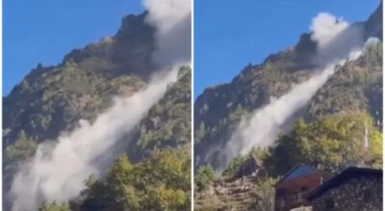
A dry landslide has been falling continuously in the Manaslu area of northern Gorkha district since Tuesday morning, according to the local ward chair, putting the spotlight on one of the most remote corners of the Nepal Himalaya. Kaldhen Chhewang Lama, the local ward chair, said the landslide is occurring at Kyrak of Chumanubri Rural Municipality-5, and that a large slide is also coming down at Bumrang, a point on the route from Kyrak to Serang Gumba, about half an hour's walk away. The ongoing slope failure has raised immediate concern for a high-altitude area where walking trails are the main connection between settlements and religious sites.
Continuous falls at Kyrak and Bumrang
According to Ward Chair Lama, the landslide is not a single burst of debris but a continuing process, with material coming down repeatedly since Tuesday morning. The main site lies at Kyrak in Chumanubri Rural Municipality-5, a ward in the high northern belt of Gorkha district that falls within the Manaslu region.
Lama further stated that a large dry landslide is falling at Bumrang, on the route from Kyrak to Serang Gumba. That site lies about half an hour's walk from Kyrak, placing the falling debris directly along a trail that links the settlement with the monastery.
The key points from the initial reports are as follows:
- Location: Kyrak and Bumrang, Chumanubri Rural Municipality-5, in the Manaslu area of northern Gorkha
- Onset: Tuesday morning, with the falls described as continuous
- Nature: a dry landslide, occurring without rainfall
- Second site: a large slide at Bumrang on the Kyrak-Serang Gumba route, roughly half an hour's walk from Kyrak
- Information source: Ward Chair Kaldhen Chhewang Lama, as carried by Khabarhub and RatoPati
The trail to Serang Gumba
Serang Gumba, which lies beyond Kyrak along the affected path, is a Buddhist monastery in the upper Manaslu region and an important religious and cultural center for the communities of Chumanubri Rural Municipality. Trails of this kind serve as lifelines in the high settlements of northern Gorkha, where steep terrain, scattered villages and limited road access make footpaths the principal way of moving between homes, fields, pastures and places of worship.
The ward chair's reference to Bumrang underscores that falling material is affecting more than one location in the same area, both at Kyrak itself and along the monastery route. In terrain where slopes rise directly above narrow walking paths, debris that comes to rest on a trail can cut off movement until it is cleared.
The wider Manaslu area takes its name from Mount Manaslu, the eighth-highest mountain in the world, and is known far beyond Nepal for the trekking routes that wind through the valleys of Chumanubri and neighboring local units. Pilgrims, trekkers and resident households alike depend on the same fragile network of high trails.
Fragile slopes of the northern Himalaya
Dry landslides of the kind reported at Kyrak and Bumrang occur without the water saturation that rain usually brings. In the high Himalaya they are commonly associated with fragile rock structure, freeze-thaw cycles, snowmelt and the loosening of debris left behind by earlier slope failures. Because they can strike in clear weather, they are particularly difficult to anticipate.
Northern Gorkha also carries a heavy geological legacy. The district was the epicenter of the April 2015 earthquake that devastated large parts of central Nepal, and communities across its northern belt suffered widespread losses. Slopes across the mountain belt were left fractured and weakened by the disaster, and landslide activity has remained a recurring hazard in the years since.
The timing of the current episode, at a time of year when rainfall is scarce in the high northern valleys, is consistent with the description of the event as a dry landslide. Such falls in fair weather are a known feature of the young, tectonically active mountains of the Nepal Himalaya, where slopes continue to adjust under the forces that raised them.
What the initial reports say
The reports published so far are limited to the ward chair's account of the falling material and its location. They do not yet specify the volume of debris involved, whether the route between Kyrak and Serang Gumba has been completely blocked, or what steps local authorities may take in response. In remote high-Himalayan wards, where communication and access are difficult, fuller details often take time to emerge.
What is clear from the account of Ward Chair Lama is that the slope activity is ongoing rather than a single event, and that it is occurring at more than one site in the same part of Chumanubri Rural Municipality-5. Residents of the Manaslu area, along with anyone planning to move along the Kyrak-Serang Gumba route, will be looking for further updates as the situation develops.