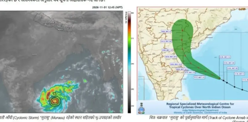
Cyclone Murasu, the weather system currently moving toward India's Andhra Pradesh coast, is unlikely to have any significant impact on Nepal's weather, according to a special weather bulletin issued by Nepal's Meteorological Forecasting Division. The division stated that the cyclone is heading toward Andhra Pradesh in India and that officials expect no notable effect on Nepal's weather from the system. The assessment, the division said, rests on weather models together with analysis of satellite imagery and data, and the bulletin was released to give the public an authoritative answer to a question that has drawn attention across the region: whether the cyclone could reach far enough to influence Nepal's skies.
A Cyclone Headed for the Andhra Pradesh Coast
The core of the bulletin is straightforward. Cyclone Murasu is on a path toward Andhra Pradesh, a state on India's southeastern seaboard, and the Meteorological Forecasting Division's analysis shows the system directed at that coastline rather than toward Nepal. On that basis, the division concluded that the cyclone will not significantly affect weather conditions in the Himalayan nation.
The bulletin serves as an official clarification at a moment when cyclones in the region frequently generate public concern. When a storm develops over the Bay of Bengal and makes headlines, people across Nepal often wonder whether it will translate into heavy rainfall, strong winds or other disruptions at home. By stating that the cyclone is moving toward Andhra Pradesh and that no significant impact on Nepal is expected, the division has sought to replace such speculation with a clear, model-backed forecast.
The division's position is unambiguous. Officials said no notable effect on Nepal's weather is expected from the system as it tracks toward the Indian coast.
How the Forecast Was Built
The Meteorological Forecasting Division did not arrive at its conclusion lightly. According to the bulletin, the assessment rests on two pillars: weather models and the analysis of satellite imagery and data. Together, these tools form the backbone of modern cyclone tracking.
- Weather models allow forecasters to project how a cyclonic system is likely to move and evolve in the hours and days ahead, offering a picture of its probable track.
- Satellite imagery gives meteorologists a real-time view of the cyclone's position, size and structure, even while the system remains over open water.
- Data analysis pulls these strands together, letting forecasters cross-check what the models suggest against what satellites actually observe.
By weighing this evidence, the division determined that Murasu's trajectory toward Andhra Pradesh does not point toward significant weather changes in Nepal. The bulletin reflects the division's role in keeping the public informed whenever a regional weather system raises the possibility, however small, of effects on the country, and it demonstrates the value of grounding public communication in verifiable meteorological evidence rather than in rumor.
Why Nepal Pays Attention to Bay of Bengal Cyclones
Nepal may be landlocked, but its weather is not isolated from the systems that form over the Bay of Bengal. Cyclones and other low-pressure systems originating in that region can, at times, influence rainfall and broader weather patterns over Nepal, which is why the public and the authorities pay close attention each time a new storm emerges. Against that backdrop, the special bulletin on Murasu functions as an early and authoritative signal that this particular cyclone does not warrant concern within Nepal.
The distinction between a cyclone that affects Nepal and one that does not often comes down to track and reach. In this case, the division's assessment leaves no doubt: the system is moving toward Andhra Pradesh, and its significant effects are expected to remain confined to that part of India rather than extending to Nepal's skies.
Reassurance for the Public
For now, the practical message for people in Nepal is one of reassurance. Officials said no notable effect on the country's weather is expected from Cyclone Murasu, and the bulletin contains no indication that the storm will disrupt conditions in Nepal. Farmers planning agricultural work, travelers arranging journeys and households going about their routines can treat the division's bulletin as confirmation that the cyclone, whatever it brings to India's southeastern coast, is not headed for Nepal.
The bulletin also underscores the importance of timely, science-based communication during regional weather events. By tracking the cyclone with weather models, satellite imagery and data, and by sharing its findings through a special bulletin, the division has provided clear information precisely when speculation about the storm is most likely to circulate. As reported by RatoPati, the cyclone is heading toward Andhra Pradesh in India and will not have a significant impact on Nepal's weather, while BBC Nepali likewise highlighted the division's finding that the system poses no notable risk to the country.
The Meteorological Forecasting Division's special bulletin thus stands as the definitive word on the matter for now: Cyclone Murasu is a story for India's coastline, not for Nepal's.